found it:
Analysis Of Flight 77 Flight Path by a Former Air Force Pilot
As a pilot and former Air Force navigator, I was interested in the flight paths of the various aircraft on their way to their targets. It was fairly simple to find the WTC routes, but I have yet to see a map showing the route flown by the aircraft that was said to have hit the Pentagon. So I read some of the reports and put together the attached maps....
...The description also said the airplane appeared to line up on the White House before making a right 270 degree turn to collide with the Pentagon. The map I drew ( see Attack Path ) is one which meets all the conditions in the description, and is consistent with what I know about how large airplanes behave at low altitude (I used to do airdrop in a C-141, flying at 300' AGL up to 280 knots)....
...But being unfamiliar with flying large airplanes at high speeds, the pilot wouldn't have taken into account the large radius required to make the turn. This would explain the circuitous 270 degree turn that was made to the impact point.
When he rolled out, he'd simply point the nose of the airplane at the center courtyard of the Pentagon and dive toward his target. What he wouldn't know without experience is that when you dive, you accelerate the airplane and the lift increases. This causes the nose to rise, which would cause him to overshoot the target. In a panic, he would push forward on the controls and overcompensate, which would account for eyewitness descriptions of the airplane striking the ground short of the Pentagon.
Of course, this is all speculation, not facts.
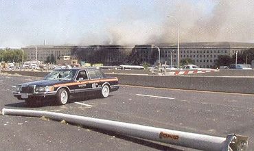
I started this analysis because I was curious about why at 9:40 a.m. on a clear day in the Nation's Capital and major tourist destination, there is not ONE photo or video of the airplane at any point in this route. None of the excuses (no cameras, not near any landmarks, etc.) make any sense â hell, there were both photos and video of the Concorde on fire, and that wasn't anywhere near a tourist spot.
Moreover, I'm surprised that I haven't seen this map â or ANY map â of the Pentagon airplane's approach. Given all the information that we were deluged with in the weeks after the attacks, it surprises me that this graphic was omitted.
Anyway, that's my contribution to the effort to try to make sense of an insane event. I don't know if it adds clarity or static, but it seems a part of the puzzle that has been missing.
Analysis by
Steve Koeppel
Palm Springs, CA
http://www.thepowerhour.com/postings/steves-analysis.htm
The attack path map is pretty interesting. Also the lack of any other photo's from any bystanders is puzzling too.
Josh
Analysis Of Flight 77 Flight Path by a Former Air Force Pilot
As a pilot and former Air Force navigator, I was interested in the flight paths of the various aircraft on their way to their targets. It was fairly simple to find the WTC routes, but I have yet to see a map showing the route flown by the aircraft that was said to have hit the Pentagon. So I read some of the reports and put together the attached maps....
...The description also said the airplane appeared to line up on the White House before making a right 270 degree turn to collide with the Pentagon. The map I drew ( see Attack Path ) is one which meets all the conditions in the description, and is consistent with what I know about how large airplanes behave at low altitude (I used to do airdrop in a C-141, flying at 300' AGL up to 280 knots)....
...But being unfamiliar with flying large airplanes at high speeds, the pilot wouldn't have taken into account the large radius required to make the turn. This would explain the circuitous 270 degree turn that was made to the impact point.
When he rolled out, he'd simply point the nose of the airplane at the center courtyard of the Pentagon and dive toward his target. What he wouldn't know without experience is that when you dive, you accelerate the airplane and the lift increases. This causes the nose to rise, which would cause him to overshoot the target. In a panic, he would push forward on the controls and overcompensate, which would account for eyewitness descriptions of the airplane striking the ground short of the Pentagon.
Of course, this is all speculation, not facts.
I started this analysis because I was curious about why at 9:40 a.m. on a clear day in the Nation's Capital and major tourist destination, there is not ONE photo or video of the airplane at any point in this route. None of the excuses (no cameras, not near any landmarks, etc.) make any sense â hell, there were both photos and video of the Concorde on fire, and that wasn't anywhere near a tourist spot.
Moreover, I'm surprised that I haven't seen this map â or ANY map â of the Pentagon airplane's approach. Given all the information that we were deluged with in the weeks after the attacks, it surprises me that this graphic was omitted.
Anyway, that's my contribution to the effort to try to make sense of an insane event. I don't know if it adds clarity or static, but it seems a part of the puzzle that has been missing.
Analysis by
Steve Koeppel
Palm Springs, CA
http://www.thepowerhour.com/postings/steves-analysis.htm
The attack path map is pretty interesting. Also the lack of any other photo's from any bystanders is puzzling too.
Josh