
You are using an out of date browser. It may not display this or other websites correctly.
You should upgrade or use an alternative browser.
You should upgrade or use an alternative browser.
Correction... 2015 was not the warmest year
- Thread starter jem
- Start date
Satellite temperature data measuring Earth’s lower atmosphere shows that 2015 only ranks as the third-warmest year on record, and not the warmest year as predicted by scientists relying on weather station data.
Climate scientists with the University of Alabama, Huntsville reported Tuesday the temperature anomaly for December 2015 was 0.44 degrees Celsius above the 1981 to 2010 average, fueled by an El Nino warming event. UAH scientist Dr. Roy Spencer posted on his blog that this “makes 2015 the third warmest year globally (+0.27 deg C) in the satellite record (since 1979).”
Spencer noted 1998 was still the warmest year on record, but added that since “2016 should be warmer than 2015 with the current El Nino, there is a good chance 2016 will end up as a record warm year…it all depends upon how quickly El Nino wanes later in the year.”
Read more: http://dailycaller.com/2016/01/06/s...ing-the-hottest-year-on-record/#ixzz3wWnQJzV7
UAH satellite data comes after scientists with the National Oceanic and Atmospheric Administration (NOAA) reported “year-to-date temperature across global land and ocean surfaces was 1.57°F (0.87°C) above the 20th century average” which is “the highest for January–November in the 1880–2015 record.”
Since virtually the beginning of 2015, scientists were predicting it would be the warmest on record, and, ironically, their predictions were confirmed by an El Nino warming event that appeared in late 2015.
El Nino’s are naturally-occurring events where the Pacific Ocean’s surface heats up while its depths get colder (the opposite happens during La Nina cooling events). El Nino years are often associated with warmer winter temperatures over the western and northern U.S., while the Gulf Coast and Florida see increases in rainfall. El Nino’s effects can last for months or even years.
Interestingly enough, insurers argue that El Nino has lessened natural disaster costs for 2015. An insurance industry group reported natural disasters caused $25 billion in losses in the U.S. in 2015, about $3 billion less than 2014.
Read more: http://dailycaller.com/2016/01/06/s...ing-the-hottest-year-on-record/#ixzz3wWnCEoNj
Read more: http://dailycaller.com/2016/01/06/s...ing-the-hottest-year-on-record/#ixzz3wWmxDk6V
Climate scientists with the University of Alabama, Huntsville reported Tuesday the temperature anomaly for December 2015 was 0.44 degrees Celsius above the 1981 to 2010 average, fueled by an El Nino warming event. UAH scientist Dr. Roy Spencer posted on his blog that this “makes 2015 the third warmest year globally (+0.27 deg C) in the satellite record (since 1979).”
Spencer noted 1998 was still the warmest year on record, but added that since “2016 should be warmer than 2015 with the current El Nino, there is a good chance 2016 will end up as a record warm year…it all depends upon how quickly El Nino wanes later in the year.”
Read more: http://dailycaller.com/2016/01/06/s...ing-the-hottest-year-on-record/#ixzz3wWnQJzV7
UAH satellite data comes after scientists with the National Oceanic and Atmospheric Administration (NOAA) reported “year-to-date temperature across global land and ocean surfaces was 1.57°F (0.87°C) above the 20th century average” which is “the highest for January–November in the 1880–2015 record.”
- “The December global temperature would have to be at least 1.46°F (0.81°C) below average… for 2015 to not become the warmest year in the 136-year period of record,” NOAA reported last month in its global temperature update — based on weather stations, buoys and ships measuring Earth’s surface temperature.
Since virtually the beginning of 2015, scientists were predicting it would be the warmest on record, and, ironically, their predictions were confirmed by an El Nino warming event that appeared in late 2015.
El Nino’s are naturally-occurring events where the Pacific Ocean’s surface heats up while its depths get colder (the opposite happens during La Nina cooling events). El Nino years are often associated with warmer winter temperatures over the western and northern U.S., while the Gulf Coast and Florida see increases in rainfall. El Nino’s effects can last for months or even years.
Interestingly enough, insurers argue that El Nino has lessened natural disaster costs for 2015. An insurance industry group reported natural disasters caused $25 billion in losses in the U.S. in 2015, about $3 billion less than 2014.
Read more: http://dailycaller.com/2016/01/06/s...ing-the-hottest-year-on-record/#ixzz3wWnCEoNj
Read more: http://dailycaller.com/2016/01/06/s...ing-the-hottest-year-on-record/#ixzz3wWmxDk6V
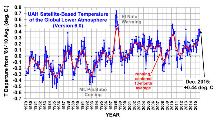
I would have to say this chart is too obvious!
The average line from start year 1979 to year 2000 was relatively lower, when comparing the average line from year 2000 to present day which is relatively higher!
The difference between two lines could be around 0.4 degree!
The trend is upwards since year 2000!
But, don't worry. God shall take care of us and our planet, if we don't!!! One way or the other!
Just my view for 2 cents!
Last edited:
Too bad satellite data does not actually measure surface air temps nor does it measure the entire earth nor is it reliable which is why it is not generally used except by denier liars.
So basically jem is being a goddamn liar.....again.
Satellites do not measure temperature directly. They measure radiances in various wavelength bands, from which temperature may be inferred.[1][2] The resulting temperature profiles depend on details of the methods that are used to obtain temperatures from radiances. As a result, different groups that have analyzed the satellite data have obtained different temperature data. Among these groups are Remote Sensing Systems (RSS) and the University of Alabama in Huntsville (UAH). The satellite series is not fully homogeneous - it is constructed from a series of satellites with similar but not identical instrumentation. The sensors deteriorate over time, and corrections are necessary for satellite drift and orbital decay. Particularly large differences between reconstructed temperature series occur at the few times when there is little temporal overlap between successive satellites, making intercalibration difficult.
Description of the data
UAH provide data on three broad levels of the atmosphere.
https://en.wikipedia.org/wiki/UAH_satellite_temperature_dataset#Geographic_coverage
From thousands of actual thermometers that are actually in the place they are measuring.....

http://data.giss.nasa.gov/gistemp/graphs_v3/
So basically jem is being a goddamn liar.....again.
Satellites do not measure temperature directly. They measure radiances in various wavelength bands, from which temperature may be inferred.[1][2] The resulting temperature profiles depend on details of the methods that are used to obtain temperatures from radiances. As a result, different groups that have analyzed the satellite data have obtained different temperature data. Among these groups are Remote Sensing Systems (RSS) and the University of Alabama in Huntsville (UAH). The satellite series is not fully homogeneous - it is constructed from a series of satellites with similar but not identical instrumentation. The sensors deteriorate over time, and corrections are necessary for satellite drift and orbital decay. Particularly large differences between reconstructed temperature series occur at the few times when there is little temporal overlap between successive satellites, making intercalibration difficult.
Description of the data
UAH provide data on three broad levels of the atmosphere.
- The Lower troposphere - TLT (originally called T2LT).
- The mid troposphere - TMT
- The lower stratosphere - TLS[3]
https://en.wikipedia.org/wiki/UAH_satellite_temperature_dataset#Geographic_coverage
From thousands of actual thermometers that are actually in the place they are measuring.....
http://data.giss.nasa.gov/gistemp/graphs_v3/
Too bad satellite data does not actually measure surface air temps nor does it measure the entire earth nor is it reliable which is why it is not generally used except by denier liars.
So basically jem is being a goddamn liar.....again.
Satellites do not measure temperature directly. They measure radiances in various wavelength bands, from which temperature may be inferred.[1][2] The resulting temperature profiles depend on details of the methods that are used to obtain temperatures from radiances. As a result, different groups that have analyzed the satellite data have obtained different temperature data. Among these groups are Remote Sensing Systems (RSS) and the University of Alabama in Huntsville (UAH). The satellite series is not fully homogeneous - it is constructed from a series of satellites with similar but not identical instrumentation. The sensors deteriorate over time, and corrections are necessary for satellite drift and orbital decay. Particularly large differences between reconstructed temperature series occur at the few times when there is little temporal overlap between successive satellites, making intercalibration difficult.
Description of the data
UAH provide data on three broad levels of the atmosphere.
- The Lower troposphere - TLT (originally called T2LT).
- The mid troposphere - TMT
- The lower stratosphere - TLS[3]
https://en.wikipedia.org/wiki/UAH_satellite_temperature_dataset#Geographic_coverage
From thousands of actual thermometers that are actually in the place they are measuring.....
http://data.giss.nasa.gov/gistemp/graphs_v3/
bump
Too bad satellite data does not actually measure surface air temps nor does it measure the entire earth nor is it reliable which is why it is not generally used except by denier liars.
So basically jem is being a goddamn liar.....again.
Satellites do not measure temperature directly. They measure radiances in various wavelength bands, from which temperature may be inferred.[1][2] The resulting temperature profiles depend on details of the methods that are used to obtain temperatures from radiances. As a result, different groups that have analyzed the satellite data have obtained different temperature data. Among these groups are Remote Sensing Systems (RSS) and the University of Alabama in Huntsville (UAH). The satellite series is not fully homogeneous - it is constructed from a series of satellites with similar but not identical instrumentation. The sensors deteriorate over time, and corrections are necessary for satellite drift and orbital decay. Particularly large differences between reconstructed temperature series occur at the few times when there is little temporal overlap between successive satellites, making intercalibration difficult.
Description of the data
UAH provide data on three broad levels of the atmosphere.
- The Lower troposphere - TLT (originally called T2LT).
- The mid troposphere - TMT
- The lower stratosphere - TLS[3]
https://en.wikipedia.org/wiki/UAH_satellite_temperature_dataset#Geographic_coverage
From thousands of actual thermometers that are actually in the place they are measuring.....
http://data.giss.nasa.gov/gistemp/graphs_v3/
Interesting. In the past you have argued that satellite temperature data is more accurate than temperature stations... and that is why we should support satellite readings over surface temperature stations. Quite a reversal on your part.
I guess you only support particular sources of data when they support your agenda.
ok, I'll bump ya, since you seem to be the only one who still believes in global warming and I'm the only one who believes in global cooling, do you ever do any matchups with sunspots to your co2 models?bump
Interesting. In the past you have argued that satellite temperature data is more accurate than temperature stations... and that is why we should support satellite readings over surface temperature stations. Quite a reversal on your part.
I guess you only support particular sources of data when they support your agenda.
As opposed to the denier liars here like you, piezoe and jem I've always known that the satellite data is not reliable and have NEVER said otherwise, liar.
I'll tell you what. I'll not call you idiots liars if you admit to being ignorant.
ok, I'll bump ya, since you seem to be the only one who still believes in global warming and I'm the only one who believes in global cooling, do you ever do any matchups with sunspots to your co2 models?
What the fuck are you babbling about? There is no credible climate expert that believes otherwise. Are you just trolling?
I'll make it simple. If you "believe" in global cooling, you are an idiot. Or you can admit to simply being ignorant and deluded, or a conservative, same thing.
When this el nino cycle is over... it will be interesting to see where the temps are.
Right now, short term, we are warming because of the el nino cycle. We are having very significant rains on the west coast in the U.S. as expected when the el nino cycle in the oceans is this warm. We are hoping all this rain alleviates our drought conditions which are typically caused by cool periods.
The question is... is man man co2 causing any extra warming.
Right now, short term, we are warming because of the el nino cycle. We are having very significant rains on the west coast in the U.S. as expected when the el nino cycle in the oceans is this warm. We are hoping all this rain alleviates our drought conditions which are typically caused by cool periods.
The question is... is man man co2 causing any extra warming.
I would have to say this chart is too obvious!
The average line from start year 1979 to year 2000 was relatively lower, when comparing the average line from year 2000 to present day which is relatively higher!
The difference between two lines could be around 0.4 degree!
The trend is upwards since year 2000!
But, don't worry. God shall take care of us and our planet, if we don't!!! One way or the other!
Just my view for 2 cents!